Welcome to Niagara-on-the-Lake! My name is David and I will be your Time Travelling Tour Guide today. During this tour, we will go back and forward in time mostly between now and June 18th 1812. Back then, the town was simply named Niagara but many still referred to it as its former name: Newark.
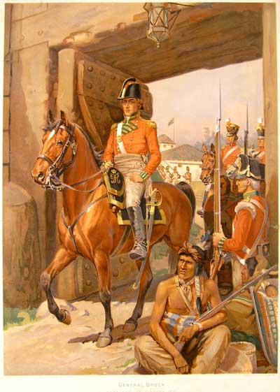
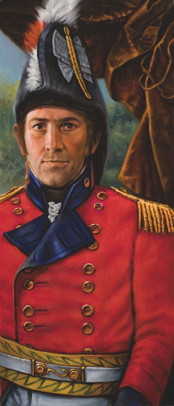
General Isaac Brock’s previous week was quite eventful. He had a lot on his mind as the situation was heating up on both sides of the Niagara River between the United States of America and the Province of Upper Canada. The subtle tension in the air made him realize that the new general officer’s hat he had ordered for himself a few weeks back directly from England had not arrived in town yet…or maybe it was simply delivered to the wrong place?
Let’s go back in time and walk along with General Brock through 1812 Niagara as he visits some of the key places where it could have been delivered by mistake.
Before we begin, it is important to mention that the town was completely consumed by fire in 1813. Therefore, the places we are about to visit, with the exception of the church, no longer exist. We do know of their past existence from writings and images from the time and you will find included in this tour as much visual support and descriptions as we could find for each stop.
Keep your smart phone or other device close as you will be invited to visit a few valuable outside links. All you need to do is to follow the directions that will be given to you. The written text below includes all the images and appropriate links you will need on our journey. I can assure you that we will find Brock’s hat!
Are you ready to come with me and be a time traveler? You are about to embark on a voyage back in time, to discover and visit some significant landmarks that were here over 200 years ago! Let’s go take a stroll together through the streets of 1812 Niagara! See you then!
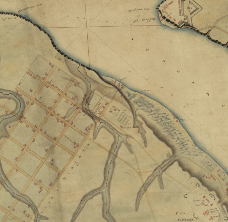
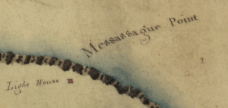
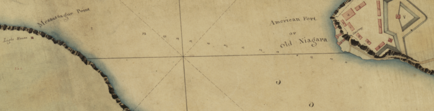
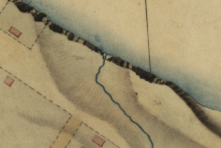
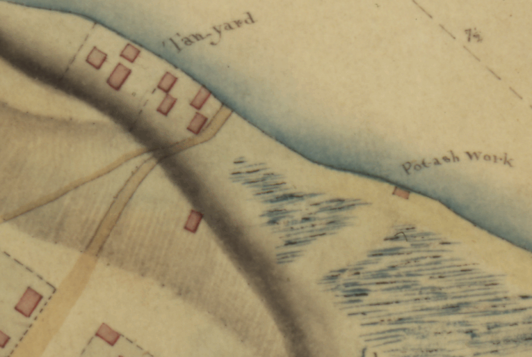
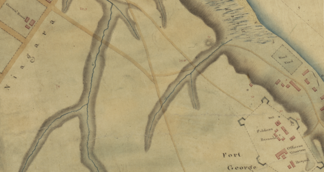
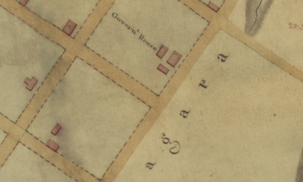
To help us navigate the young town, we will use a section of a very old map, the ‘‘Upper Canada Plan of Niagara’’ drawn in 1810 by A. Gray which you can find as part of this Niagara Historical Society website.
(Portion of the [1810] No V Upper Canada Plan of Niagara by A. Gray Asst Qr Mr Genl Quebec 20th Novr 1810 This Plan is from a Trigonometrical Survey by Lieut: Gray [Sgd] Q.M. Genls Office Quebec 1st June 1811 James Kempt Q M Genl N. America)
Let’s start our journey at the corner of the now called Front and Simcoe Streets. Follow this Google Maps link to help you get there.
1st Stop: The Lighthouse
You should now be a short stroll away from Fort Mississauga National Historic Site of Canada. The word ‘‘Mississauga’’ is derived from ‘‘Mis-zaagiing’’, a word from the Algonquin language family meaning “those at the great river mouth”. Surprisingly, the fort is not where we are going with General Brock… Let’s now go back in time to June 18th 1812, before the war, before this old fort in the middle of the golf course was even an idea… Are you ready? You might get a little dizzy…
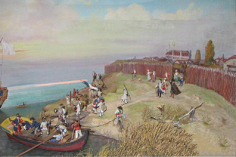
You made it! Welcome to 1812! You have arrived at our destination and should now see this:
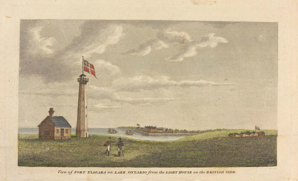
View of Fort Niagara on Lake Ontario from the Lighthouse on the British Side (Source)
Welcome to the Mississauga Point Lighthouse, the first lighthouse built on the Great Lakes. This location, where the Niagara river meets the lake, has been a very strategic place for centuries. It has been occupied by at least three Native American tribes: the Neutral (15th century); the Seneca (late 17th century); and the Mississauga (18th century). The word ‘‘Niagara’’ itself is from the language of the Iroquois who lived on this land before the arrival of Europeans. Although many believe that this translates to ‘‘thundering water’’, Niagara might also simply mean ‘‘neck’’; the Niagara River would be ‘‘the neck between two lakes’’.
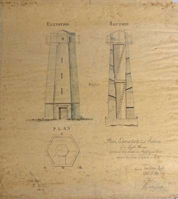
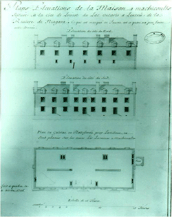
The Mississauga Point Lighthouse, on this side of the river, was constructed by the military masons of the 49th Regiment of Foot. Its hexagonal stone tower was accompanied by a separate but adjacent lightkeeper’s residence. Take a look at this copy of the original 1804 construction plans.
A 1909 copy of an 1804 original plan of the lighthouse that was erected on Mississauga Point, signed by Gustavus Nicolls and copied by J. Simpson. (Source)
Brock was asked to lend help with the construction of the 45 foot high tower, the lightkeeper’s house, and to designate one soldier from the garrison to tend the light. Dominic Henry , of the 4th Battalion, Royal Artillery, was appointed keeper. He started his new duty in June 1804 and stayed in that position for the next 10 years.
Overlooking the maritime traffic on the lake, Fort Niagara on the American side, and located at the mouth of the Niagara River, the lighthouse strategic position has been a great resource for General Brock not to mention that Dominic and his wife Mary are always eager to help. In our case, they have not seen General Brock’s new hat anywhere. We will have to continue our search.
Unfortunately the lighthouse will get damaged at the end of the American occupation in 1813. It will be dismantled in 1814 to make way for Fort Mississauga, which will incorporate salvaged stones from the once proudly standing lighthouse.
Welcome back to the present. You can now follow the path through the golf course and look at this National Historic Site if you want to; you will find a plaque commemorating the existence of the lighthouse at its center. Once you are there, to give you some important background perspective, we will have a brief overview of Fort Niagara’s story on the other side of the river. Take your time, enjoy the scenery and simply come back to our tour when you are ready to continue.
Fort Niagara
There you are! Are you ready to learn about Fort Niagara? The fortifications across the river were not always named this way. To understand the full story of the fort I need to bring you a little further in time…to 1678!!! Let’s go back together to have a better perspective about Fort Niagara’s history.
The land across the river has only been American territory since 1783 and the Fort occupation by American Forces only began in 1796. Considering our stroll with General Brock through Niagara takes place in 1812 and that the history of the fort began more than 130 years prior to that date, this American occupancy is, to put it mildly, quite recent.
Fort Niagara was originally built to protect the interests of New France in North America by René-Robert Cavelier, Sieur de La Salle in 1678. Its original name was Fort Conti. In 1687, the Governor of New France, the Marquis de Denonville, constructed a new fort at the former site of Fort Conti. He named it Fort Denonville, after himself, and posted a hundred men there.
Fort Denonville, Niagara River, controlled by New France (Archives nationales d’outre-mer (France), Author unknown, Pencil drawing made in 1687)
Because of weather and disease, only twelve survived the first frigid winter in the fort. The post was abandoned the very next year. It is not before 1726 that the French will return again and build the “House of Peace”, a trading post to appease the Iroquois.
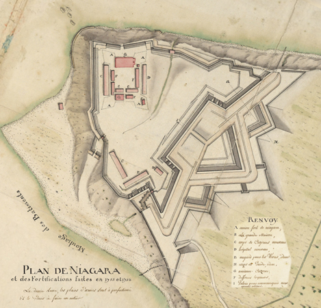
The fort was expanded to its present size in 1755 because of increased tensions between French and British colonial interests. You will find included here some original plans and pictures of this final structure.
Plan de Niagara et des fortifications faites en 1755 et 1756 [Altered closeup] based on Captain Pierre Pouchot’s “Plan de Niagara et des Fortifications faites en 1755 et 1756”, drawn about October 18, 1756 to document the first year’s progress of the fort.Fort Niagara, ‘‘French Castle’’, Blue print (Source)Fort Niagara “House of Peace”, photo by Anne Jennsen, May 25th, 2005 (Source)
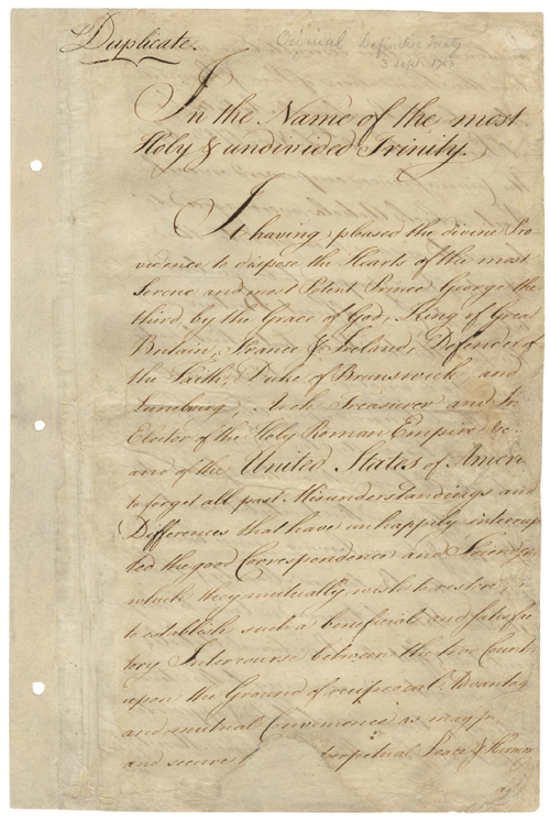
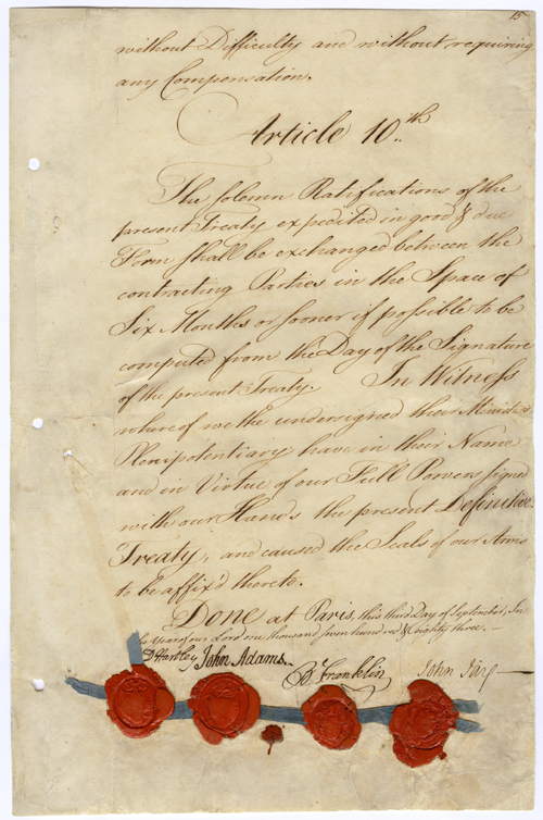
Fort Niagara played a significant part in the French and Indian War, and fell to the British in July 1759. It then served as the Loyalist base in New York during the American Revolutionary War for Colonel John Butler and his Butler’s Rangers, a militia in the command of the British Army. It was not until the end of the American War of Independence and the signature of the Treaty of Paris on September 3, 1783 that the fort was ceded to the United States. However, the region remained effectively under British control for thirteen years. Only after the signing of the Jay Treaty did American forces occupy the fort in 1796. Here is a copy of both treaties.
Treaty of Paris (1783), Signature page (Source)The original Jay treaty, page 1. (Source) The full document is available here.
Of course, you are not expected to remember all those details! If anything, simply remember that Fort Niagara was first under French control, then British, and finally American. Also try to remember about James Butler and his Rangers…
You are now invited to go back where we started and we will continue our search for General Brock’s new hat through Niagara. Our next stop will be at the corner of Front and Victoria Streets; simply walk along Front Street away from Fort Mississauga for 2 blocks.
2nd Stop:
Brock’s Seat and The Addison House
You should now be at the corner of Front and Victoria streets. As you can imagine, none of these private residences were here in 1812. Let’s go back again and find out what was actually here in Brock’s time.
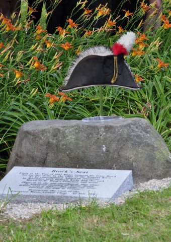
Brock’s Seat
According to a widely accepted local folklore story, there was once a large boulder located on the western bank of the Niagara River at the foot of Victoria Street, where you are right now, opposite to Fort Niagara. On this large, flat-topped stone, General Brock would sit and study the citadel across the river.
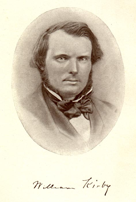
At the end of the century, in November 1893, the poet William Kirby will have the stone relocated, saving it from being forgotten or destroyed by the developing town. He will write the following sonnet for the occasion:
Photograph of William Kirby, with his signature, ca 1865. (Source)
Brock’s Seat
“Yes! Place it in the old churchyard, this stone In honoured memory of heroic Brock, Whose seat it was, oft pondering the shock Of war to come, while lake and river shone With sunset glory. His clear eye alone Foresaw the way to victory – to unlock The people’s hearts and fill them from his own. Yes! Set it fitly in the sacred ground, And every year with garlands be it crowned, Forgetting never, our deliverance stood At the full price of his devoted blood, The price he paid, amid the battle roar, As Queenston Heights bear witness ever more.”
Believe it or not, you will be able to see and even sit on Brock’s Seat later in the tour! For now, here is a picture of that famous boulder with the hat we are looking for today…
Image provided by St-Marks Church, Niagara-on-the-Lake
The Addison House
Also at this street corner was a building known as ‘‘The Addison House’’. It was the very first residence of Reverend Robert Addison who was the first Anglican minister at what our 1810 map refers to as the ‘‘English Church’’. Addison moved in the house at his arrival to Niagara in 1792.
A letter written by Peter Russell, a member of the Legislative Council of Upper Canada, on August 6th of that same year, refers to the “Addison House” as one of only three adequate houses in the town, with the rest being considered as ”Very simply constructed dwellings”…
In 1808, having moved to Lake Lodge, a little outside of town, Addison deeded the property to William and James Crooks. Try to remember these characters as we will meet them again later on. Unfortunately, no representation or plans of the house survived, but we will visit Addison’s church later on.
Have you seen Brock’s new hat somewhere? No? Me neither. Let’s first go back to present time and make our way to our next stop.
To reach our next historical landmark, continue walking along Front Street for another 2 blocks until you reach King Street. As you get there, you will cross on your left hand side your first restroom opportunity in the public building in the middle of the park.
3rd Stop:
The Upper Canada Gazette
At this point you should be at the edge of the riverfront Queen’s Royal Park and have a beautiful white gazebo overlooking the river and the lake from your perspective. Find yourself a place to sit as we visit our next stop: The Upper Canada Gazette.
Welcome to 1812 again! First of all let’s have a look at this area on our map.
The Gray map clearly indicates the existence of a tanyard on the riverbanks, which is an area of the tannery set aside for the operation of tanning vats. A tannery is a facility converting hides or skins into leather. Tanning vats are simply big containers or tanks in which the hides are soaking in different solutions including dyes along the process. We will not spend too much time on this facility, as there is very little information to be recovered about the old tannery, but knowing its location will help you later on.
Also, a little upstream, the map indicates a Potash producing facility. Potash is a type of fertilizer, a salt that contains potassium in water-soluble form. It is positioned on the river bank as well because, as per the tanning process, the manufacturing of potash involves the use of water. Let’s just mention that, with both facilities located at this very spot, in 1812, there was most probably very interesting smells floating in the air…
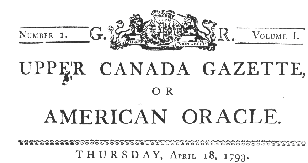
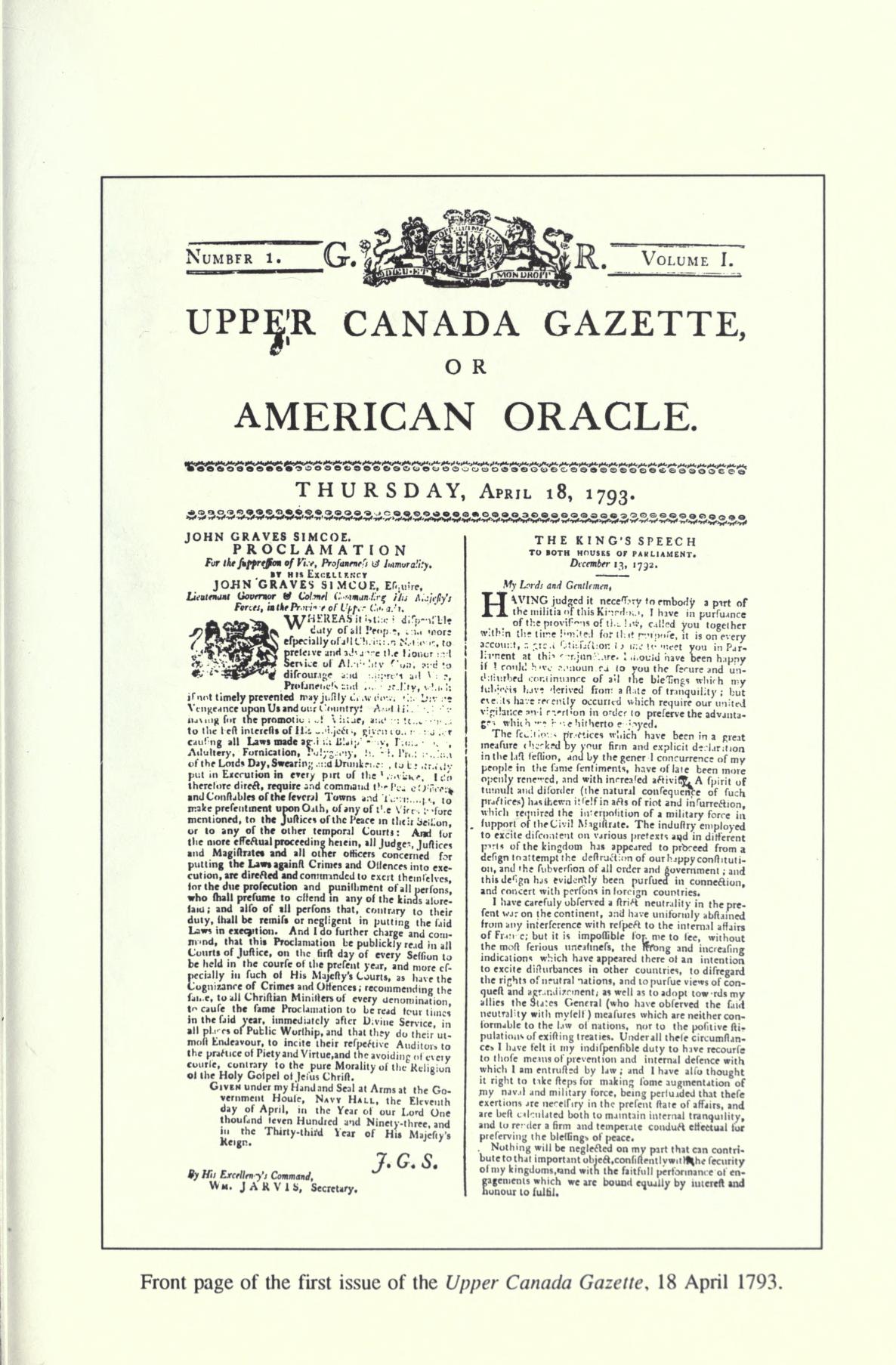
Our main focus here will be ‘’The Upper Canada Gazette or American Oracle’’, the first newspaper printed in Upper Canada from 1793 to 1849. This site is not where the Gazette is printed in 1812 but it will be the publishing location of ‘’The Gleaner’’, which will be, from 1817 to 1837, one of the most prominent newspaper in Canada.
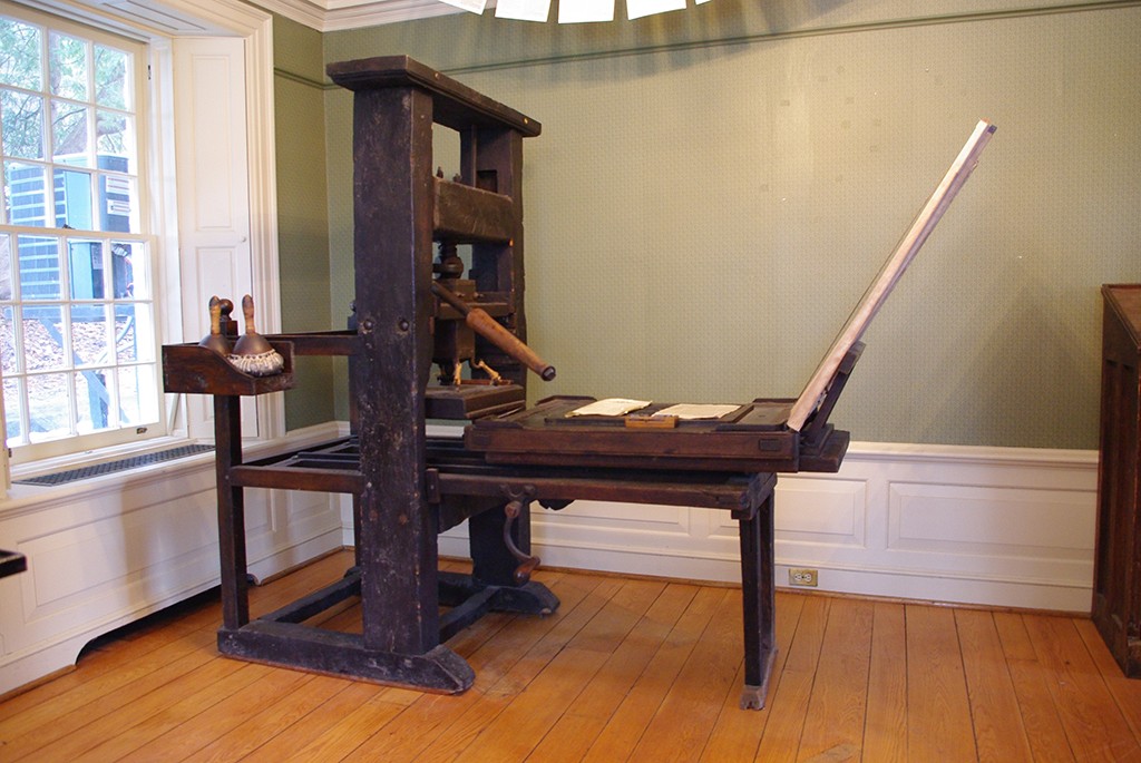
The Upper Canada Gazette was first printed and published right here in Niagara before the office was moved to the town of York, or as you know it ‘’Toronto’’. The Gazette’s circulation was primarily in Upper Canada and in the United States but people also subscribed to the newspaper from Great Britain and its other colonies that will eventually make the rest of Canada. Here is an image of the front page of the very first edition published on Thursday April 18th 1793, followed by a picture of the press that most probably printed it:
The Roy Press, Niagara Parks, Mackenzie Printery Museum (Source)
This press actually survived the passage of time and made it in pretty good shape to the 21st century where it is part of the Mackenzie Printery Museum located in Queenston! A very interesting place to visit.
The Gazette played a sizable role in the shaping and evolution of the province as it dramatically increased communication, allowing information to travel within and beyond Niagara. Over the years, it published a myriad of vital information including official proclamations from General Brock himself. Here you can see a short announcement also from the first edition:
As you can see, not all news are bad; this particular one probably created quite a reaction around town! According to some sources, the brewery was also built on the bank of the river, in this general area.
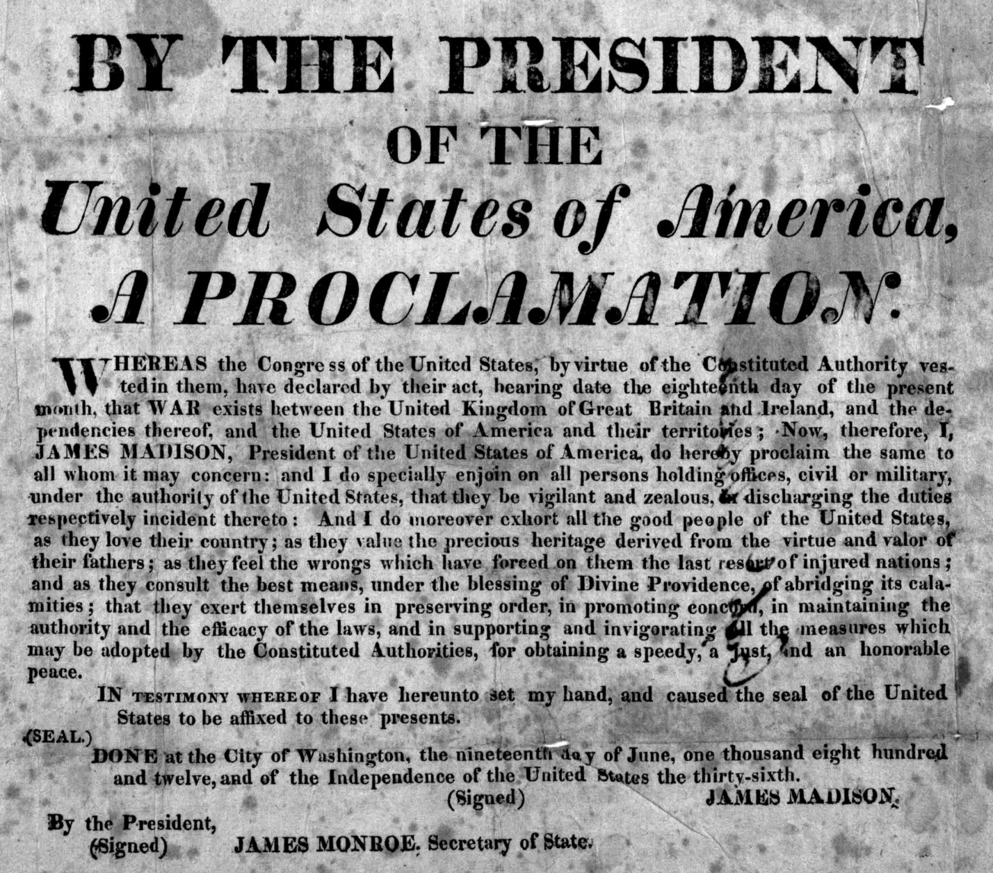
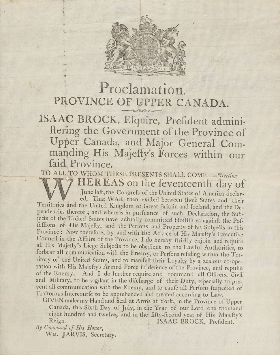
Let’s ground ourselves back into our June 18th 1812 reality. As we are walking along today trying to find General Brock’s new hat, a very important act is being passed by the United States Congress in Washington. Tomorrow, President James Madison will sign a proclamation and have it published throughout the United States: a declaration of war between the United States of America and the United Kingdom of Great Britain and Ireland, which includes the territories of lower and upper Canada. A picture of this proclamation is included below.
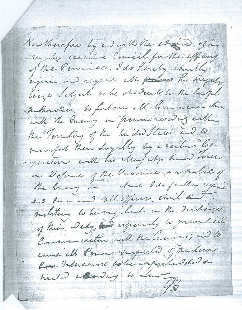
This proclamation marks the beginning of the war of 1812 which will have quite an impact on this region. A lot will happen following this publication and Brock will obviously be one of the first to learn about it but, with the ‘’Internet’’ not even being an idea for another 150 years, the telephone not being invented by M. Bell before 1876 and even the telegraph not being a usable communication device before the mid 1830’s, well, it will simply take a little time for this historically charged piece of information to arrive to Niagara. One week from now, General Brock will finally get the news. He will then handwrite and send his own proclamation to be published, warning the population on this side of the border of the newly proclaimed state of war between the two countries. See below both handwritten and printed versions of Brock’s proclamation:
Brock’s Handwritten Proclamation about the newly declared warBrock’s proclamation about the newly declared war, printed
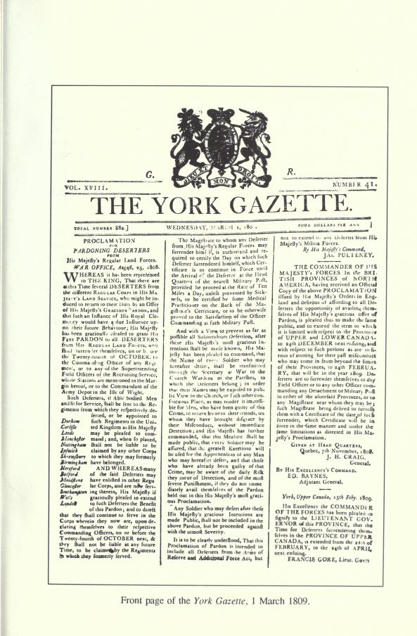
At the time of this last proclamation, the printer of the Gazette is named John Cameron. The name of the newspaper had been changed in 1807 to ‘’The York Gazette’’, since it has been printed in York (Toronto) since 1798. You can see here an example of the new cover page of the newspaper:
General Brock’s hat is nowhere to be found around here either. Let’s go forward in time to our lovely park shall we?
Today, there is here, at the corner of Front and King Streets, some commemorative plaques dedicated to the existence of the early newspapers in Upper Canada, which played such a monumental part in the creation and development of this country. To learn more about the Gazette, you can follow this link to a very complete free Ebook, from which almost all the previous images were borrowed, at Openlibrary.org, entitled: ‘‘The Upper Canada Gazette and its Printer, 1793-1849’’
Right now, take a moment to enjoy the park and let’s meet again at our next stop when you are ready. To get there, simply walk up along King Street for 1 block. You will be at the corner of King and Prideaux Street. See you there!
4th Stop:
The Court House and Prison
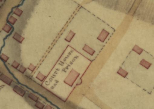
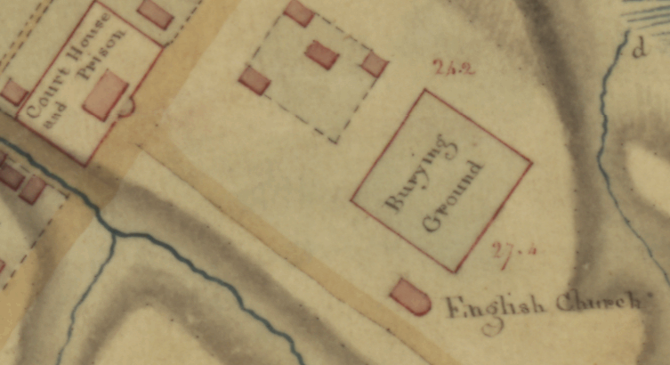
You should now be at the corner of Prideaux and King Streets. This corner has always been an important location in Niagara-on-the-Lake. In 1812, this was the location of the Courthouse and Prison. Let’s go back in time again and see what we can find out about this building.
During the settlement of Newark in 1791, the British government instructed David William Smith, the Deputy Surveyor General, to lay out the new Town. Smith’s official plans included a public square in the Mary, William, Mississauga, and Butler Streets block, and the Courthouse to be at Mississauga and Queen. The idea was to have the center or town out of Fort Niagara’s fire range. Nevertheless, during the very early settlement, a small group of politically active merchants made most of the decisions concerning the new capital town.
These merchants-magistrates maintained the focus of the town close to the waterfront, ignoring Smith’s official plans. An advertisement signed by Ralfe Clench, Superintendent of Public Buildings, in 1795 for ‘’nails for the use of Jail and Courthouse’’, shows how early a Jail and Courthouse were necessary. It was erected on lot 32, where you are standing right now, at a cost of £300, providing suitable facilities for the county seat.
No plans or drawings of the original courthouse survived the passing of time but the few pieces of information that reached our modern times are enough to give us a very good idea what it might have looked like.
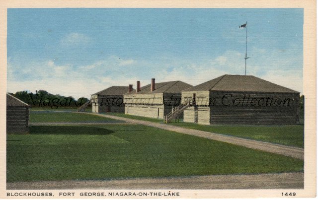
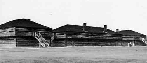
First of all, we know that ‘’ the courthouse had been of the blockhouse variety, and would not be visually missed. ‘’ We also know that it will completely burn down in 1813, which indicate it is most probably made out entirely of wood. Interestingly enough, during the same early settlement period, blockhouses were also constructed inside Fort George, which is only a short walk from here, to house officers and soldiers. We do know what these looked like as they will be reconstructed in 1939. The plans, dimensions and reconstruction of the blockhouses at Fort George were based on historical writings and similar buildings of the same era at Fort York. It is then fair to assume that the first Courthouse and Prison located right here, resembled the barracks at Fort George. Here is a picture and an old postcard of these reconstructed buildings:
Niagara Historical museum collection, Object ID 2007.005.007The three reconstructed blockhouses at Fort George. Photo by Richard J. Young (Source)
Later during the war, there will be up to 400 prisoners confined in the Courthouse and Prison as well as the BlockHouse (probably meaning one of Fort George’s building), many charged with disloyalty. This means that the building standing right here in 1812 was of substantial size and probably able to accommodate half this number of prisoners.
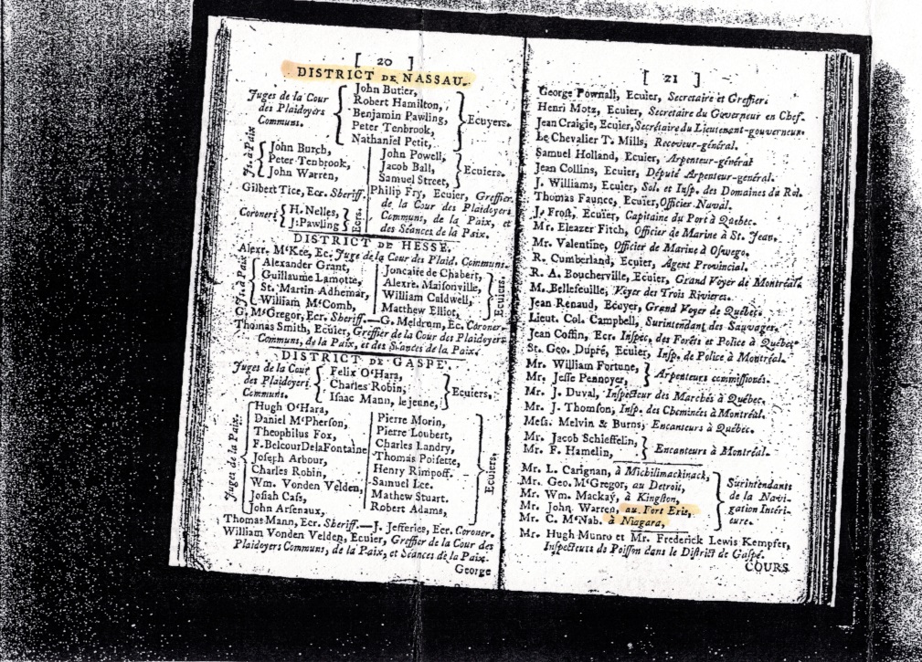
In 1788, John Butler, whom we discussed earlier in the Fort Niagara section with his Buttler’s Rangers, was appointed one of the first Justice of the Court of Common Pleas. Butler, with the help of other gentlemen of the time, dealt with civil matters between subject and subject for the Nassau District, which the town of Newark was part of. You can see his name being right on top of the following page of this ‘’Quebec Almanac’’ from 1793:
Niagara Historical museum collection, Quebec Almanac, 1793
This document from Quebec City is in French which is logical. ‘‘Juges de la Cour des Plaidoyers Communs’’ translates to ‘‘Justices of the Court of Common Pleas’’.
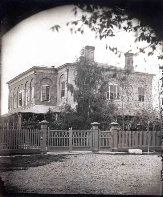
As we mentioned earlier, the Courthouse will be consumed by fire in 1813. The new Courthouse will be built on the outskirts of town and will look like this:
Niagara Historical museum collection, Courthouse & Jail, Photograph, 2008.001.017
When it was completed in 1818, the second Courthouse was considered to be one of the finest buildings in Canada. It was used as a Courthouse and jail until 1847. One very interesting fact is that in the Spectator of St. Davids, 1816, published by Richard Cockrell, there is an advertisement signed by Ralfe Clench, Clerk of the Peace, District of Niagara, “for the materials required for building the Jail and Courthouse, to be delivered between 1st June and 13th July: 50 toises stone, 330 bbls. lime, 200 thousand brick, 20 thousand shingles, squared timber, 12 x 14 of oak and 20,000 feet of pine lumber.” This is the same Ralfe Clench advertising for ‘’nails for use of Jail and Courthouse’’ 20 years earlier, in 1795. Small town isn’t it?
No trace of Brock’s new hat here either; let’s continue our journey through time by first getting back to the 21st century.
Our next stop is right across the street. You are now at the end of Prideaux Street and the beginning of Byron Street. To get there, you only have to cross King Street and walk for 2 minutes on Byron until you reach a big stone church on your left. See you there!
5th Stop:
St. Mark’s church
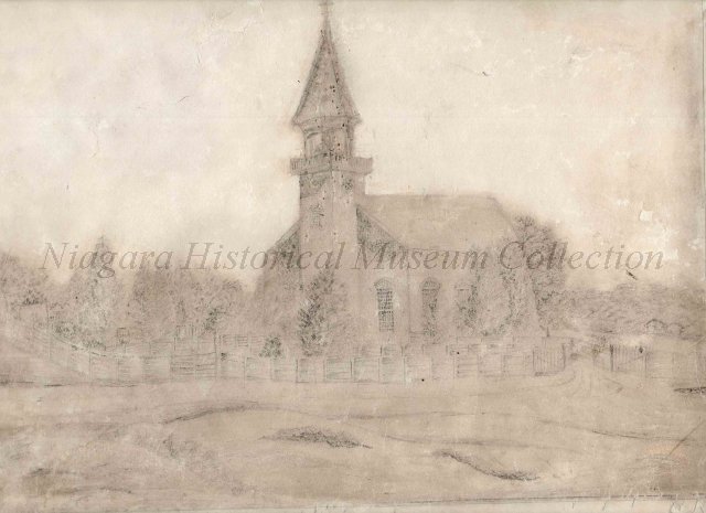
Now, do you remember when we talked about Reverend Robert Addison? Yes? Let me present to you his newly built church! Well, I guess that last statement will only be true if we go back to General Brock’ era again, isn’t it? I do get a little confused going back and forward in time all day long! Well, what are we waiting for! Let’s go!
Welcome back. Considering our present time of June 1812, St. Mark’s church is barely 3 years old. A lot will happen here but, for now, things are rather calm. Let’s go through a little history of this truly remarkable place.
In May 1791, the Anglican Church appointed Robert Addison to be resident clergyman in Niagara and within a couple of months he set sail for Canada. He brought with him a silver chalice and his library of more than 1500 books, inherited from his father.
When he arrived in Niagara the following July, Addison discovered that his “parish” included all of the little villages that were springing up from Fort Erie to Ancaster and from York (Toronto) to London, including the Native Reserve along the Grand River. There was no church building in town, so Addison held services in the Masonic Lodge or the Indian Council House. The congregation included most of the important people of the day, such as Lieutenant Governor John Graves Simcoe, Colonel John Butler and Major General Sir Isaac Brock. The land granted by the Crown for the church was located midway between the town and Fort George. Work began quickly on the construction of a fine building; workers and parishioners carried stones from the escarpment. It seemed for a while that the project was too ambitious for the small congregation. Addison only held his first service in the church 18 years after his arrival, in 1809. Here is probably the oldest surviving drawing of the church which will be drawn in 1820:
Simple 1820s drawing of St. Mark’s Church on paper. The view is from a house near the stone barracks and is attributed to Deborah Muirhead. Faded to the point where much detail has been lost but is still a valuable historic drawing. (Niagara Historical museum collection, 988.218)
The British Forces will later use St. Mark’s Church as a hospital. Not long after, the Americans will also use the space as a hospital and storehouse when they will capture Fort George in 1813. Army cooks will use some of the low gravestones as chopping blocks, leaving scars that will still be visible 200 years later as well as trenches dug throughout the Churchyard for American defenses.
Unfortunately, Reverend Addison has not seen the hat we a looking for. We will have to search for it elsewhere. Let’s go forward to present times and find out what is happening with the Church more than two centuries later!
Today, the building remains the oldest Anglican Church in continuous use in Ontario. You are invited to visit this historical landmark at your leisure. The Reverend’s collection of books is located in the Addison Library, inside the Addison Hall, right across from the church. The hall is not always open but if it is, you can peek through the library’s doors. The collection is available to anyone for research but by appointment only.
Canada, Ontario, Niagara-on-the-Lake, Saint Mark’s Anglican Church, Addison Library, a repository and educational library of antique books which survived the War of 1812 (Source)
Do you remember Brock’s Seat? Well, it is now here as well! Simply, go around at the back of the church and follow the path into the cemetery. The picture you saw previously was taken here in 2012.
St. Mark is a very ‘’musical’’ church today and has exceptional acoustic qualities. For that reason, a lot of the concerts organized by Music Niagara are hosted here.
To learn more about Music Niagara’s concerts schedule go here.
Finally, for more details about this amazing historical site, follow this link to the church’s very complete website.
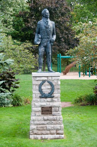
When you are ready to continue, simply have a stroll across Simcoe Park towards the downtown area. There is a path starting right across from the church and ending up at the corner of King and Queen Streets. As you are getting there you are invited to learn about Lieutenant Governor John Graves Simcoe and Chloe Cooley’s story. There is, in the middle of the park, a statue or the Governor if you wish to take a picture.
Simcoe and Chloe
(going across Simcoe Park)
Statue of Lieutenant Governor John Graves Simcoe. Simcoe Park, Niagara-on-the-Lake
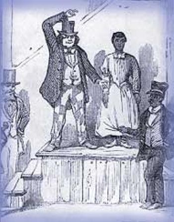
To tell you this next story, I need to bring you back a little further this time… back to 1793…
On March 14th, 1793, Chloe Cooley, an enslaved black woman in Queenston, was bound, thrown in a boat and sold across the river to a new owner in the United States. In an act of defiance she yelled out screams of resistance to the abuse committed to her by her owner, Sergeant Adam Vrooman. She resisted so fiercely it caused Vrooman to require the assistance of two other men in an attempt to control her. Her desperate struggles and screams were witnessed by Peter Martin and William Grisely. Martin, a former slave, black Loyalist and fellow veteran of Butler’s Rangers, and Grisely, a neighbour who witnessed the event, brought the incident to the attention of Lieutenant Governor John Graves Simcoe.
Artist’s rendering of Chloe Cooley being offered for sale. Source: Black History Canada.
Simcoe moved to try abolishing slavery in the new province. The elected members of the executive council, many of whom were merchants or farmers who depended on slave labour, disagreed and saw no need for emancipation. A compromise was reached and, on July 9th 1793, an Act was passed that prevented the further introduction of slaves into Upper Canada and allowed for the gradual abolition of slavery although no slaves already residing in the province were freed outright. It was the first piece of legislation to limit slavery and set the stage for the great freedom movement of enslaved African Americans known as the Underground Railroad.
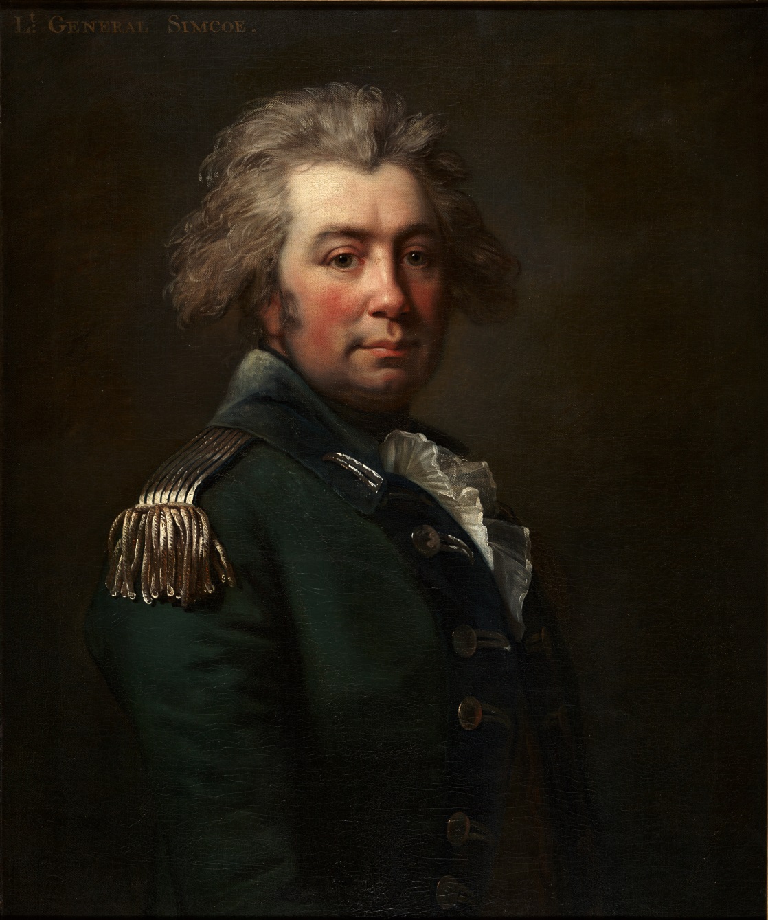
Portrait of John Graves Simcoe (1743-1808) by Jean Laurent Mosnier. Marilyn & Charles Baillie Special Collections Centre, Toronto Reference Library, 5th floor (Source)
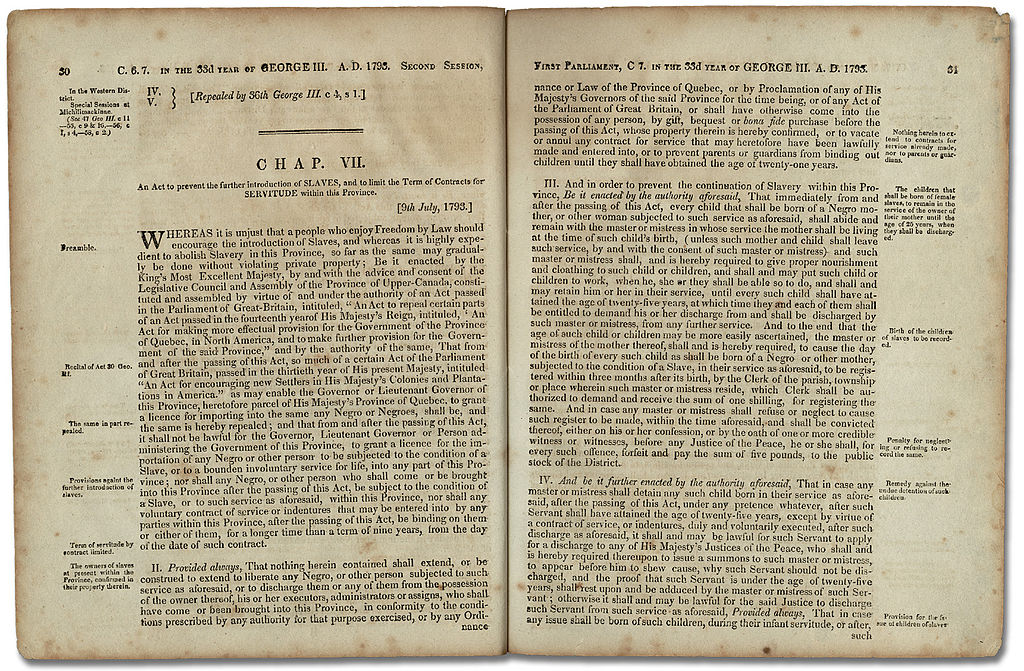
The law, titled ‘‘An Act to Prevent the further Introduction of Slaves and to limit the Term of Contracts for Servitude within this Province’’, stated that while all slaves in the province would remain enslaved until death, no new slaves could be brought into Upper Canada, and children born to female slaves after passage of the act would be freed at age 25. The bulk of the text is due to John White, the Attorney-General of the day. Of the sixteen members of the assembly, at least six owned slaves. Here is a copy of this very important piece of legislature, the first such law enacted anywhere in the world, that was created right here in this little town. Here is a copy of the Act:
Legislative Assembly of Upper Canada – The text of “An Act Against Slavery”, 1793. This image is available from the Archives of Ontario (Source)
Miss Chloe’s screams were heard and her torments were not in vain…
You should now be across the park at the very busy corner of King and Queen Streets. It’s all very British around here! To reach our next stop, you need to go across to the very opposite corner and continue walking on King, away from the river. At the corner of Market Street you will see a public restroom building on your right. There is at our next stop, in this day and age, an old train station converted in a quaint little café. You are welcome to take advantage of that situation to take a break if you need. Time travelling at the rate we are doing it today can be quite exhausting! I am used to it by now but feel free to sit down for a bit while going back to our next stop. Let’s meet again at the Café, corner of King and Market. You should be able to see it from where you are right now.
6th Stop:
The Government House
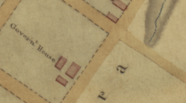
You should now be inside or around that little Café we talked about earlier. Once again, nothing of what you see around you was there in Brock’s time, this was a massive and very important lot stretching in between Queen, King, Johnson and Regent Streets. Ready to go back again?
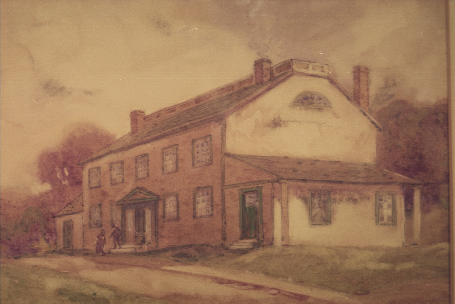
Welcome back to 1812! Let me present to you the Government House. The house and other related buildings are actually the only ones on the whole square lot. The Government House is where figures from the government reside while being in Niagara and, as he is part of the government as well, the main residence of General Brock. It is perfectly located in between Fort George and the beginning of town, directly facing the fort across the commons.
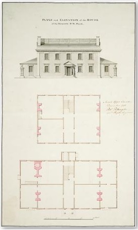
Government House was not built for that purpose. It was originally built by David William Smith who arrived in town around the same time as Reverend Addison did. Smith was offered the post of Acting Deputy Surveyor General in 1792 by John Graves Simcoe. He helped in creating the layout of the town plan of Newark in 1794, the one that was not respected in terms of the Courthouse location. He occupied different governmental position in Upper Canada until he went back to England in 1802. Here are some plans of the house drawn in 1797:
Plans and Elevations of the House of the Honorable D.W. Smith, artist Robert Pilkington, drawings on paper, 1797, Georgian elegance overlooking the Commons. Courtesy of the Toronto public library.
Smith’s house was large and elegant, and painted in the best style. According to Robert Pilkington, who drew the plans you just looked at, ‘‘the house was eighty feet long by forty feet wide, with a hall in the middle and a room on each side measuring twenty feet square. There was another room off each side that measured twenty by fourteen feet. There was a staircase at the end of the hall that was circular with one turn. The house had four fireplaces, a vault, large kitchen, pantry, and a baking place off the fireplace. The upstairs was sixty-five feet divided into four rooms.’’
Another source describes Smith’s house in these terms: ‘‘In point of size and elegance, the house of Colonel Smith, […], is much distinguished from the rest. It consists of joiner’s work, but is constructed, embellished and painted in the best style; the yard, garden and court are surrounded with railings, made and painted as elegantly, as they could be in England. His large garden has the appearance of a French kitchen-garden, kept in good order…’’
The house was evidently one of the largest residence in town. It was put for sale in 1799 when the Government, as well as Smith, had left Niagara for York. It was then offered to be a grammar school but the idea was rejected because it was still within fire range of Fort Niagara. It became the Government House in 1800, probably because of its location, beauty and size. Smith is still the owner of the house and lots today, in 1812.
“Residence of D.W. Smith, Surveyor-General, Upper Canada”, from a drawing by Elizabeth Simcoe. Artist unknown.
You can imagine that, being the core of the government in town, a lot have happened within its walls. We can easily picture General Brock, at his desk, writing by hand all sorts of official documents and proclamations before sending them to the printers to be published in the next Gazette. The most important one, as we have seen earlier, will come shortly, when the news of the new declaration of war will reach Niagara. General Brock’s new hat has still not been delivered at the house today. Let’s continue searching.
Ouf! I don’t know about you but all this time travelling is making me dizzy! Our next stop is literally at the next corner. When you are ready, continue on King Street going away from the busy Queen Street until reaching Johnson. Cross Johnson Street and you will be there…well at the right place but not the right time yet!
7th Stop:
James Crooks and the Lord Nelson
You should now be at the corner of Johnson and King Street. As a visual, you should have seen an Irish Pub at that very corner. Let’s go back to Brock’s time again and discover why we stopped here.
Here we are again! Well, in theory we didn’t move much…Same place, different times… hmmm interesting but confusing thought isn’t it? Anyway, let’s continue before we get trapped in this new rabbit hole!
The two lots facing King Street in between Johnson and Gage (the next street up) are currently owned by Mister James Crooks. The same James Crooks to whom Reverend Addison deeded his house when he moved to Lake Lodge in 1808. Newark is a pretty small town! This is most probably the location of Crook’s residence as well, but this will not be our main focus here.
James Crooks
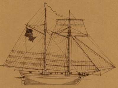
James and his two brothers, William and Francis, arrived in Niagara around 1792 from Scotland. When the Fort expanded in 1795 they moved their business to Newark, Upper Canada. Unfortunately, Francis died in 1797, but William and James continued their operation. As well as provisioning the military, their business includes grain shipments to Lower Canada, brewing and distilling, and the production of potash which we talked about earlier on the river bank. To move their products, the Crooks brothers had a ship built right here in Niagara, the schooner Lord Nelson. It was launched on May 1st, 1811, a little over a year ago, as an unarmed merchant schooner to carry merchandise between Upper Canadian ports. Here is, in drawing, the Lord Nelson’s sail plan:
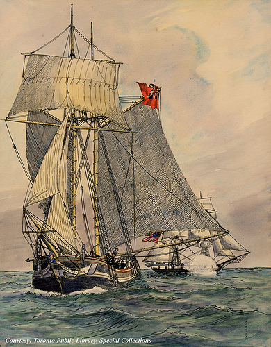
Not even 2 weeks ago, on June 5th 1812, The Lord Nelson was stopped on the lake’s waters by United States Navy Lieutenant Melancthon T. Woolsey aboard his ship, the Oneida. It was then illegally seized on suspicion of smuggling. Here is a drawing of this already historical event:
Schooner “Lord Nelson”, being captured by the American brig of war “Oneida” off Niagara-on-the-Lake, Toronto Public Library Special Collection
Mister Crooks is definitely very upset about this and has been very actively trying to get his ship back. Without the Lord Nelson, his business becomes much more complicated to operate. The news has gone around the whole region very quickly; this event went against the usual ‘’good manners’’ shared between the military on both sides of the river and confirmed General Brock’s suspicions that tension is rising up quickly along the border.
Unfortunately, Crooks will never see his schooner again. As we learned earlier, both countries are now officially at war with one another. The Lord Nelson will be renamed the ‘’USS Scourge’’, an American warship. It will later sink during the war along with another ship named ‘’Hamilton’’ during a night storm on Lake Ontario on Sunday, August 8th 1813. According to Ned Myers, one of the survivors from the sinking, eight men from the Scourge were saved, and about 42 were lost… Well, the bad news for us is that Mister Crooks has not heard of any hat delivery at his property nor does he know if it was on the Lord Nelson with the other goods when it was seized last week. Let’s only hope it wasn’t and that General Brock’s new hat might still be in Montreal, Quebec city or in the middle of the Atlantic somewhere…
To complete the Lord Nelson’s story, you need to know that the site of the sunken ships is now designated as a National Historic Site of Canada. Both underwater vessels are under special protection due to their historical and cultural significance and because they contain human remains.
After some more recent efforts into mapping and documenting the shipwrecks, combined with the help of today’s advanced technology, you are invited to take an underwater virtual tour of the Scourge, formerly James Crooks’s Lord Nelson, following this link.
Crook’s descendants persisted for generations and finally won compensation for the illegally seized schooner. In 1914, 97 years later, they were awarded $5000, plus 93 years of interest. The total compensation came to almost $24 000, reduced to around $15,500 after deduction of legal expenses, and was paid by the United States government to the 25 descendants of James Crooks. In that case I guess the saying was true: Good things do come to those who wait!
Our next stop will be our last one. Unfortunately, we haven’t found General Brock’s hat yet but we will, I promise.
You are now invited to continue on King Street until the next corner. Turn left on Castlereagh Street. You are going to 43 Castlereagh. Before entering the building, we need to relive General Brock’s last months during the newly declared war to give you some historical context. This is a sad story that doesn’t end very well but you need to experience it to understand. You can slowly walk to our next stop while reading if you want. If you decide to do so, please make sure to take a look at what’s in front of you in the present time, from time to time, because in the past, the building you want to go to will only be built in the future. Oh my! This sounded so confusing… We are almost done as this will be our last time travel for the day.
8th Stop:
Brock’s Last Stand
Welcome back to 1812. As we know now, both countries are now at war but the news will take a week to arrive here. Popular belief says that, around June 25th 1812, General Brock was hosting both American and British officers for dinner at Fort George when the news of the declaration of war arrived. The relationship between both military forces was surprisingly very civilized before the war. One could almost have thought there was no border at all as people were able to cross the river back and forth without any major problem. After hearing about their newly declared animosity, the officers decided to continue their meal. Folklore has it that Brock would have calmly addressed his guests by saying something like: ‘‘Well, there is no need to waste some perfectly good food. Let’s finish our friendly gathering tonight, we will escort you back to the river after and tomorrow we will be at war.’’ It would have been done as such and after toasts to both the King and the President, the Americans would have peacefully returned to Fort Niagara. It is important to mention that the news of the war was very unwelcomed on both sides of the Niagara River.
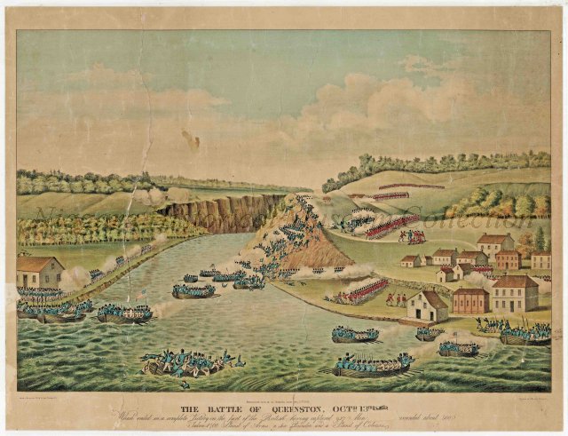
Summer went by without any major event. The next fall, on October 13th 1812 at approximately 3 a.m., the Americans under the command of General Rensselaer began invading Upper Canada at Queenston, under the dimmed light of the half moon. Sleeping at Fort George, General Brock woke up to the sounds of battle up the river and instantly realized what was going on. Hastily, riding his trusted horse Alfred, he went to Queenston with his aides-de-camp, Lieutenant Colonel John Macdonell and Captain John Glegg.
War of 1812: General Sir Isaac Brock on Alfred by J.D. Kelly
Brock quickly saw that his troops were outnumbered by the invading American ones. He knew the importance of controlling the high grounds at Queenston Heights and wanted to reclaim them before reinforcements arrived. He began to counter attack with the 200 soldiers he had with him.
‘‘The Battle of Queenston, Octr. 13th, 1813 [sic]’’, aquatint after James Dennis (Library and Archives Canada, Acc. No. 1970-188-517, W.H. Coverdale Collection of Canadiana)
His efforts were put off by American artillery fire. With his troops pinned down, Brock mounted his horse and ordered them to continue their charge by yelling “follow me, boys!” Dressed up with his cocked hat, white breeches and scarlet coat, he was easily recognizable as a commander of some sort. During this charge, Major General Sir Isaac Brock was shot by an American marksman who had hidden behind a tree.
“War of 1812: The Death of General Brock at The Battle of Queenston Heights” by John David Kelly (1896)
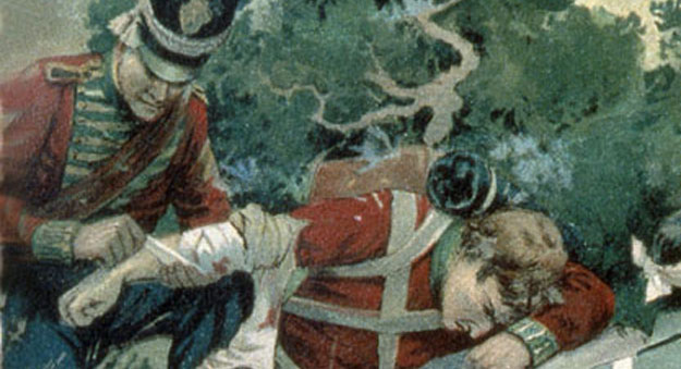
Shot in the chest with a musket ball at close range, he died almost instantly. His body was then carried by his aide-de-camp, Glegg, to Patrick McCabe’s Stone House in Queenston.
Patrick McCabe’s Stone House in Queenston
On reaching the heights, Macdonnell heard of Brock’s death and immediately led a charge of his own against the invaders. It was thrown back and Macdonell badly wounded in three or four places. He finally died shortly past midnight after a day of excruciating pain.
After the death of Isaac Brock at Queenston Heights, John Macdonell led a charge against the Americans, but was mortally wounded himself. (Detail from a painting by John David, courtesy Library and Archives Canada/C-000273)
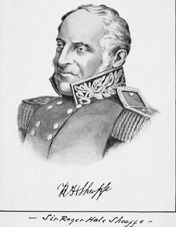
British Major General Roger Sheaffe, immediately replaced Major General Brock and succeeded in securing the heights. American troops were ultimately defeated; some of them receded back to their side of the river and others were captured. The rest is history.
General Sir Roger Hale Sheaffe (Library and Archives Canada/C-111307)
Before going further
PRESS PLAY
The burial of Brock and Macdonell took place at 10:00 a.m. on October 16th, a day of great mourning in Niagara. The streets were crowded as never before with people from all over the province. The troops, regulars and militia, stood with reverse arms on King Street opposite Government House and all flags were at half-mast. Handel’s Dead March, which is playing in the background right now, was played by the military band, filling the air with sadness as the procession began towards Fort George with Alfred, Brock’s trusted horse, leading the cortege. Even the Americans across the River, took time to pay their tribute; a gun salute would be performed at Fort Niagara, “as a mark of respect due to a brave enemy.” General Brock’s first burial site was inside Fort George.
Commemorative tombstone of General Sir Isaac Brock, inside Fort George
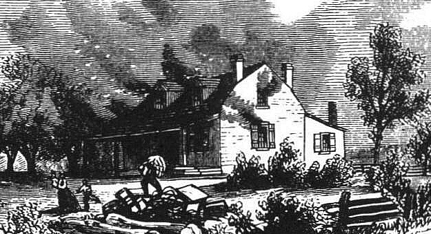
On May 27th 1813, several months later, the Americans successfully invaded Niagara, or ”the village of Newark” and occupied the town until December 10th, 1813. It was on this date that the town was completely destroyed by the retreating U.S. troops. Here is an extract from an American newspaper about this final attack.
‘‘[We, at Fort Niagara] commenced the fire with red-hot shots directed against the village of Newark, opposite the Fort, and on the third or fourth shot we discovered that the courthouse was on fire. Soon after, we discover the brewery and tan house on the bank of the river to be on fire, which buildings were all consumed…’’ (from the New York Columbian, (file in mercantile library, Philadelphia)
Joseph Willcocks band of American and pro-American Canadians living in Upper Canada engaged in widespread looting and burning farmhouses (Public domain)
After that first strike coming from Fort Niagara’s canons, the Americans burned almost every building in town, including the Addison House, the Brewery, the Tannery, the Government house and even St-Mark’s Church, which only the stone walls remained. The Light House was spared from the carnage due to its importance in guiding the maritime traffic on the lake. Newark’s inhabitants were given only hours to carry their belongings into the snow-covered streets. Everything now had to be rebuilt… I warned you this was a sad story…
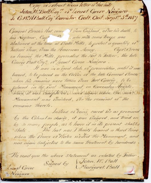
Life went on and the town was slowly reconstructed. You can still see today quite a few of these post-war buildings still standing; this would be a completely different tour. Unfortunately, General Brock’s original cocked hat, the one he wore at his last battle, was lost in time…The new hat he had ordered from England finally arrived shortly after his passing. Here is a letter from 1887 that talks about the arrival and history of this new hat.
This letter describes the route that the hat that was ordered by General Brock and how it came into the possession of the Ball Family at Ball’s Mills and how the Niagara Family at Locust Grove obtained it and donated it to the Museum. It is signed by John W. Ball and Margaret Ball.General Brock’s new hat in its protective case (Niagara Historical Society & Museum)
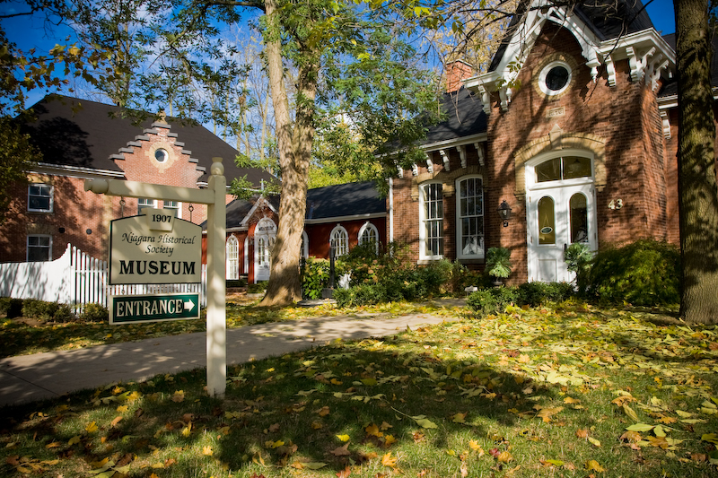
Obviously, this brand new hat is not so new anymore two centuries later but it is now on display at the Niagara Historical Society Museum, which should be right in front of you by now!
Niagara Historical Society Museum, Niagara-on-the-Lake
There is a small entry fee to visit the museum which is well worth it! General Brock’s hat is always on display somewhere inside. You are now welcome to go in and simply ask the front desk: ‘’Have you seen Brock’s hat?’’ They will know how to guide you! As for me, my role of time travelling tour guide is now done. I hope you enjoyed our stroll through 1812 Niagara with Major-General Sir Isaac Brock. If so, please consider making a donation to the Niagara Historical Society & Museum today. Have a very nice day and see you later… or before maybe!
This tour was made a reality with the collaboration of the Niagara Historical Society & Museum who graciously granted the use of their images and were also involved in text and fact revision.
”Have you seen Brock’s Hat?”
was imagined, researched and created by David Levesque
And is intended to remain at all time
accessible and free of use for all.
1 Reply on “Have you seen Brock’s Hat?”
David!
A detailed and respectful journey through time. Words and images that bring you back to a very vilolent time. An absolutely brilliant work!


David!
A detailed and respectful journey through time. Words and images that bring you back to a very vilolent time. An absolutely brilliant work!
Cheers!
Matt Phillips